
Torres del Paine
Patagonia's headline act, and surprisingly manageable: the W Trek covers about eighty kilometres in four to five days between staffed refugios, so you carry clothes and snacks rather than a full camp.
- Best forWalkers & hikers · Adventure seekers · Photographers
- In October6°C · 24 rainy days
- Ideal stay5–7 nights
- Approx. flying time~13h 05m from Los Angeles
- CurrencyCLPChilean peso
- LanguageSpanish
- Local time07:184h behind the UK
- PlugsType C / LBring an adapter
- Drive on theRightOpposite to the UK
- Dialling code+56
Why go
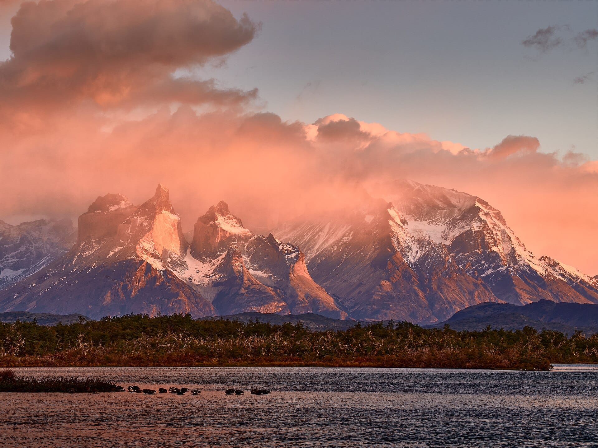
Granite towers, hanging glaciers and lakes in improbable blues fill a compact corner of Chilean Patagonia, and the park is built around walking. The W Trek covers around 80 kilometres in four or five days between staffed refuges, so packs stay light. Guanaco graze the open steppe, condors ride the thermals above the ridges, and the wind is a constant presence rather than an occasional feature.
Everything hinges on booking. Beds and campsites are run by the park authority and by concession operators, and they sell out months ahead for the December to February peak. Puerto Natales is the staging town, reached by bus from Punta Arenas airport or across the border from El Calafate. October, November and March are quieter, colder and often windier. Non-walkers can still see a great deal by road.
- Ideal stay
- 5–7 nights
- The vibe
- Wind-scoured, granite, exhilarating
From our guides
Granite towers, the blue sprawl of Grey Glacier and guanacos posing on cue. The catch is admin — campsites and refugios must be booked months ahead for the December-to-February season. Wind is the real adversary; anchor your hat.
Featured in Ten national parks for your first proper trek
Things to do
-
Base of the Towers
A long day up a moraine to the lake beneath the three granite towers. Start before dawn if you want them lit red, and expect a rough final hour.
-
French Valley
The middle arm of the W, a hanging valley with a glacier shedding avalanches across from the path. Turn back at the first viewpoint if the wind is up.
-
Grey Glacier
A wall of blue ice at the end of the western arm, seen from the path, by boat across the lake or on a guided ice walk with crampons.
-
Guanaco and puma
Guanaco are everywhere on the eastern steppe, and the park holds one of the highest puma densities in South America. Tracking trips run at dawn and dusk.
-
Salto Grande and Lake Pehoé
A short, easy walk to a powerful waterfall between two lakes, with the Cuernos rising behind. This is the best of the park without a multi-day hike.
-
Refuge life
Bunk rooms, communal dinners served in vats and a drying room full of steaming socks. It is a large part of why people remember the trek.
Getting there
-
Fly to
Puerto Natales (PNT)
Nearest airport to Torres del Paine, about 71km away as the crow flies.
-
Then
To Puerto Natales
Puerto Natales (PNT) has limited seasonal flights and is about 10 minutes from town; most visitors fly into Punta Arenas (PUQ) and take a bus for around three hours. Buses meet the flights.
-
On the ground
Getting around
Buses run from Puerto Natales to the park entrances in about two hours in season, with catamarans and shuttles connecting the trailheads inside. The W Trek links staffed refugios over four to five days, all of which must be booked months ahead.
Public transport: Seasonal buses, park shuttles and the Lake Pehoé catamaran cover the W Trek properly, so a car is not required.
Flights
Los Angeles Torres del Paine, Chile
Fly from anywhere — search 4,000+ airports worldwide.
Roughly 13h 05m in the air from Los Angeles (LAX), estimated from the distance — check for a direct route. Pick a month to see every available flight with live prices.
Check dates and prices
Pick your departure date, then your return.
Search flightsNot sure when? Compare fares across a whole month.
Flight times are estimates; prices open on Google Flights.
When to go
Daytime highs run from about 2°C in July to 14°C in February. Wettest in March, with rain on about 24 days.
The year at a glance — pick a month for detail
October6° · rain 24 daysCold and often wet.
Monthly figures averaged from daily records for 2020–2024 at this location (ERA5 reanalysis). Live conditions from MET Norway, CC BY 4.0.
Where to stay
Refugios with bunks and camping inside the park, all-inclusive lodges at the entrances, and everything from hostels to boutique hotels in Puerto Natales. No self-catering inside the park.
-
Best base overall
Puerto Natales
The gateway town two hours from the park, where the gear rental, the briefings and the buses are, with hostels through to smart hotels. It is windy and plain, but everything you need is here.
Find stays in Puerto Natales -
Closest to the sights
The refugios on the W Trek
Bunks and meals inside the park, so you walk rather than commute. They are booked out months ahead and food and beds are priced accordingly.
Find stays in The refugios on the W Trek -
Best with children
Lago Grey and Serrano sector
Hotels and lodges near the park entrance for day walks without the full trek, with the glacier boat close by. Isolated, so you eat where you sleep.
Find stays in Lago Grey and Serrano sector -
Best value
Cerro Castillo or the Villa Renoval end of Natales
Simple hospedajes and cabins well below park prices, with a kitchen for your own cooking. You are further from everything and will rely on the morning bus.
Find stays in Cerro Castillo or the Villa Renoval end of Natales
Worth knowing before you book: Refugios and campsites for the December to February season open for booking in winter and sell out quickly, and they are run by two separate operators. Book both before flights.
Search everything else in Puerto Natales by budget. These are indicative budget bands in GBP per night for two people, not live quotes or guarantees of hotel type. Check your dates, guests, taxes and final price on Booking.com.
Good to know
- Book ahead
- Refuges and campsites open reservations several months out and fill fast for the peak season. Without a booking you are not permitted to walk the route.
- Wind
- Gusts regularly exceed 100 kilometres per hour in summer. Secure hats, use trekking poles and treat exposed sections above the lakes with respect.
- Getting there
- Fly to Punta Arenas, take a bus to Puerto Natales in around three hours, then a park bus for a further two. El Calafate in Argentina is the other approach.
- Fires
- Open fires and stoves outside designated areas are banned after past wildfires. Rangers enforce this strictly, and so should everyone else.
- Pack this
- A waterproof shell and trousers, layers for four seasons in a day, and Chilean pesos in cash for refuge extras where signal and card readers fail.
Further afield

Related articles
Quick answers
When is the best time to visit Torres del Paine?
Daytime highs run from about 2°C in July to 14°C in February. Wettest in March, with rain on about 24 days.
How long should I spend in Torres del Paine?
Our suggestion: 5–7 nights.
How do I get to Torres del Paine?
Puerto Natales (PNT) has limited seasonal flights and is about 10 minutes from town; most visitors fly into Punta Arenas (PUQ) and take a bus for around three hours. Buses meet the flights.
Do I need a car in Torres del Paine?
No. Seasonal buses, park shuttles and the Lake Pehoé catamaran cover the W Trek properly, so a car is not required.
What currency and language are used in Torres del Paine?
Currency: Chilean peso (CLP). Language: Spanish. Plugs: type C and L.
Who is Torres del Paine best for?
Best for walkers & hikers, adventure seekers and photographers. In a phrase: wind-scoured, granite, exhilarating.